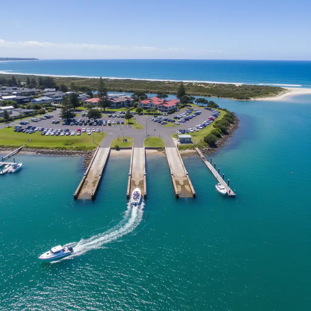
The Omaha boat ramp, located at the entrance to Whangateau Harbour, is a premier launching facility offering all-tide access for trailer boats targeting the outer Hauraki Gulf. While it provides excellent proximity to Little Barrier Island and prime snapper grounds, skippers must navigate the harbour entrance bar with caution and strictly observe the boundaries of the nearby Cape Rodney-Okakari Point Marine Reserve.
Omaha, situated just an hour north of Auckland, is more than just a pristine beach destination; it is a strategic gateway for serious anglers and recreational boaters. The Omaha boat ramp serves as the critical launch point for accessing some of New Zealand’s most prolific fishing grounds, including the channels surrounding Little Barrier Island and the deeper waters towards Great Barrier Island. However, utilizing this facility requires specific local knowledge regarding bar crossings, marine reserve boundaries, and tidal flows.
What Are the Omaha Boat Ramp Facilities Like?
The Omaha boat ramp is widely regarded as one of the best-maintained facilities in the Rodney district, yet it presents specific challenges that every skipper must understand before hitching up the trailer. Located on the estuary side of the Omaha spit, within the Whangateau Harbour, the ramp is designed to handle a significant volume of traffic, particularly during the peak summer months.
The facility features a concrete multi-lane ramp that generally allows for all-tide access. However, “all-tide” comes with a caveat for larger vessels. At dead low tide during spring cycles, the bottom of the ramp can become shallow, and the drop-off into the channel mud can be problematic for boats with deep drafts or heavy keels. For the average trailer boat (5m to 7m), the ramp is usable throughout the tidal cycle, provided you stick to the center of the marked lanes.
One of the key advantages of this ramp is the pontoon structure. The floating pontoon allows for safe boarding and disembarking, which is particularly useful when managing children or elderly passengers. It also streamlines the launching process, allowing solo boaties to tie off quickly while parking their vehicle. During summer, local council wardens are often present to manage the flow of traffic and ensure that ramp etiquette is followed efficiently.
How is the Parking and Trailer Storage?
Parking at popular New Zealand boat ramps can be a nightmare, but Omaha is relatively well-equipped, provided you arrive early during peak season. The dedicated boat trailer parking area is situated adjacent to the ramp. It is paved and marked specifically for long vehicle combinations.
Parking Capacity and Overflow
On a standard weekend, there is usually ample space. However, during the height of summer (December through February) and on public holiday weekends, the main trailer park fills up rapidly—often before 7:00 AM. Once the designated trailer bays are full, parking becomes significantly more difficult. Overflow parking often spills onto the grass verges along Omaha Drive, which can result in a long walk back to the ramp. It is strictly prohibited to park in areas marked for cars only if you have a trailer attached, and enforcement is rigorous with ticketing common for non-compliant vehicles.
Wash-down and Amenities
Post-trip maintenance is crucial for salt-water vessels. The Omaha facility includes a wash-down area, although water restrictions can sometimes apply during drought periods. It is advisable to bring your own hose fittings and connectors, as these often go missing. Public toilets are located right next to the ramp, kept in reasonably good condition by the local council. There are no fuel facilities directly at the ramp or in the immediate residential streets of Omaha. The nearest fuel station is in Matakana or Warkworth, so ensuring your tanks are full before leaving the highway is a critical logistical step.
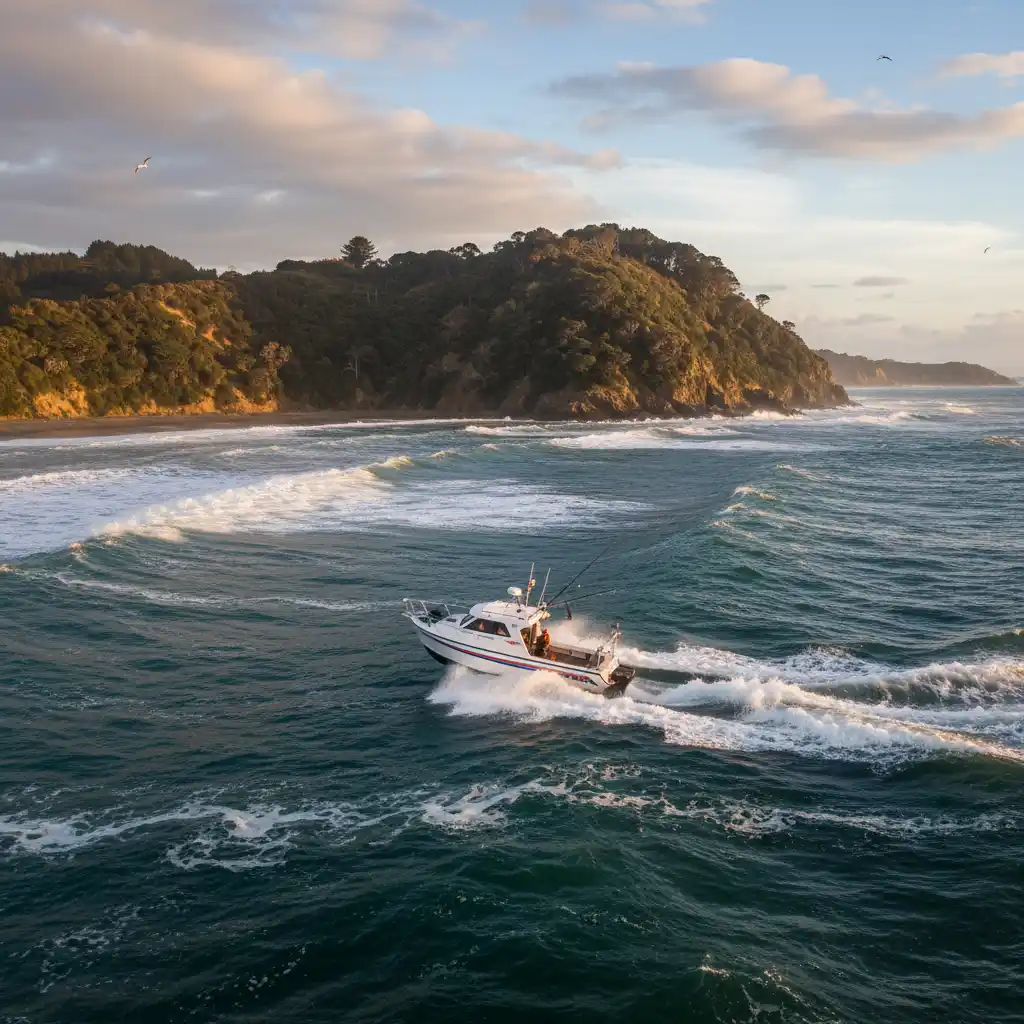
How to Safely Cross the Omaha Bar?
While the ramp itself is sheltered within the harbour, accessing the open ocean requires navigating the entrance to the Whangateau Harbour. This is a bar crossing, and like all bar crossings in New Zealand, it demands respect and preparation.
The Omaha bar is generally considered one of the more manageable bars in the region compared to the notorious West Coast entrances, but it can still be treacherous in the wrong conditions. The entrance is relatively narrow and faces the open swell coming from the northeast. When an easterly swell opposes an outgoing tide, the waves at the entrance can stand up aggressively, creating breaking waves that are dangerous for small craft.
Best Practices for the Crossing
- Check the Tide: The safest time to cross is usually approaching high tide or at slack high water. Avoid crossing at mid-outgoing tide if there is any significant swell running, as the current rushing out of the estuary collides with the incoming waves to create steep, breaking seas.
- Lifejackets On: It is a legal requirement and common sense that every person on board must wear a properly fitting lifejacket when crossing a bar.
- Call the Coastguard: Log a trip report (TR) with Coastguard on VHF Channel 64 or 60 before you attempt the crossing. Let them know your intentions and close the report once you are safely outside (or back inside upon return).
- Read the Water: Stop inside the heads and observe the sets. Look for the deepest channel water, which typically hugs the Ti Point side (the northern headland), but sandbanks shift frequently. Local knowledge is invaluable here; watch where other experienced skippers are tracking.
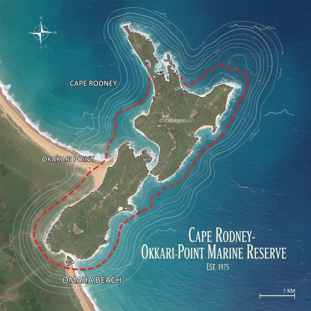
Where are the Marine Reserve Boundaries?
One of the most critical aspects of fishing from Omaha is knowing exactly where you cannot fish. The Cape Rodney-Okakari Point Marine Reserve (commonly known as the Goat Island Marine Reserve) is located just north of the Omaha bay. This was New Zealand’s first marine reserve and is a strict no-take zone.
The boundaries extend from Cape Rodney to Okakari Point and reach 800 meters offshore. If you launch from Omaha and turn left (north) to head towards Leigh, you will skirt the edge of this reserve. The penalties for fishing inside the reserve—or even having fishing gear deployed while drifting through it—are severe, including confiscation of vessels and massive fines. Modern chart plotters usually have the reserve clearly marked, but visual landmarks are also essential. Look for the yellow triangular markers on the cliffs.
It is worth noting that because of the reserve, the spillover effect has populated the surrounding areas with larger fish. However, you must ensure you are well clear of the boundary line before dropping a bait. A good rule of thumb is to maintain a significant buffer zone to account for boat drift caused by wind and current.
What Are the Best Fishing Spots Outside the Reserve?
Once you have cleared the bar and the marine reserve, Omaha serves as the launchpad to some of the Hauraki Gulf’s most productive fishing grounds. The diversity of the underwater topography here allows anglers to target a wide range of species.
1. Little Barrier Island (Hauturu)
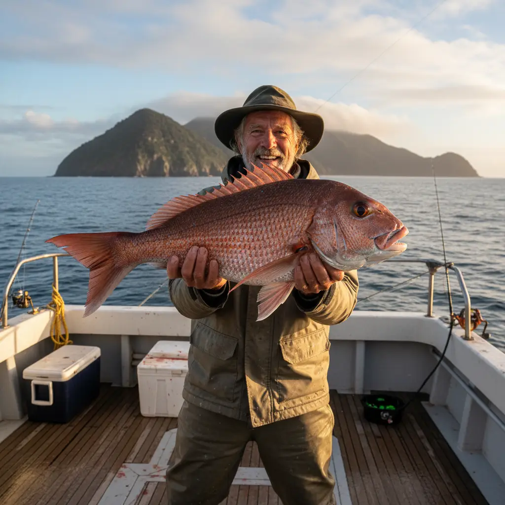
Located approximately 12 nautical miles from the Omaha ramp, Little Barrier Island is a mecca for big snapper and kingfish. The boulder banks and weed lines around the island hold massive fish. The western side of the island offers some shelter from easterly winds. Stray-lining with whole pilchards or fresh jack mackerel into the wash (keeping a safe distance from the rocks) is a proven technique here for trophy snapper.
2. The 40-50 Meter Squiggles
Heading out past Little Barrier towards Great Barrier Island, the sea floor depth drops to 40-50 meters. This area, often referred to as the “middle ground,” is excellent for workups. In late summer and autumn, gannets diving here signal workups where pilchards are being pushed to the surface by kahawai and kingfish, with snapper cleaning up the scraps underneath. Using mechanical jigs or slow-pitch lures (sliders/kaburas) in this depth is highly effective.
3. Flat Rock
To the south-east of Omaha lies Flat Rock, a well-known structure that rises from deep water. The currents here are strong, creating an ecosystem rich in baitfish. It is a prime location for targeting Kingfish, especially using live baits or top-water stick baits during the summer months. Be aware that this spot is popular and can get crowded; etiquette suggests giving other boats plenty of drift room.
4. Omaha Bay Drifts
You don’t always have to travel miles offshore. The sandy bottom of Omaha Bay itself, just outside the bar and clear of the reserve, can be productive for panning snapper, gurnard, and kahawai. Soft-baiting over the sand at depths of 15-25 meters is a relaxing and effective way to secure a feed of table fish without burning excessive fuel.
Seasonal Fishing Tips for Omaha Anglers
Success in this region depends heavily on the season. The water temperature fluctuations in the Hauraki Gulf dictate the movement of baitfish and predators.
Spring (September – November)
As the water warms, snapper move in from the deeper water to spawn. This is the time to target the “schoolie” snapper in the 20-30 meter depths. Workups start to become more frequent. Soft baits in natural colors (bruised banana, new penny) tend to work well during this transition period.
Summer (December – February)
This is Kingfish season. The yellowtail kingfish patrol the markers, buoys, and reef structures like Flat Rock and the back of Little Barrier. Live bait (mackerel or koheru) is the gold standard. Snapper are also abundant but can be harder to catch during the middle of the day due to boat traffic; early morning or dusk sessions are superior.
Autumn (March – May)
Often considered the best time for fishing in the Gulf. The weather is generally more stable, and the fish are feeding aggressively to condition themselves for winter. This is the prime time for big workups involving dolphins and whales. Lure fishing is at its peak effectiveness.
Winter (June – August)
Fishing slows down, but the quality of fish improves. The “moochers” (large resident snapper) are found in the shallows around the rocky coastlines. Stray-lining in shallow water (5-10 meters) around sunrise can yield the fish of a lifetime, although patience is required. Gurnard also become a more common catch on the sandy bottoms.
Coastguard and Local Safety Regulations
The waters off Omaha are patrolled by the Coastguard and Fisheries officers. Safety is paramount, and the isolation of spots like Little Barrier means help can be an hour away.
- VHF Channels: The primary channel for the area is typically Channel 64 (Kawau) or Channel 60. Always monitor Channel 16 for emergencies.
- Carry Two Forms of Communication: Cell phone coverage is generally good in the bay but can be patchy behind Little Barrier. A VHF radio is essential.
- Skipper Responsibility: Always check the marine weather forecast (MetService or SwellMap) specifically for the “Auckland East” or “Hauraki Gulf” area before launching. If the wind is opposing the tide at the bar, be prepared to wait it out or cancel the trip.
By respecting the ramp etiquette, understanding the bar crossing, and adhering to marine reserve boundaries, Omaha offers some of the finest marine tourism and recreational fishing experiences in New Zealand. Whether you are chasing a trophy Kingfish at Flat Rock or drifting for a family feed of snapper in the bay, preparation is the key to a successful day on the water.
Is the Omaha boat ramp usable at low tide?
Yes, the Omaha boat ramp is generally usable at all tides for standard trailer boats (5-7m). However, extreme low spring tides may make the end of the ramp shallow, requiring caution for larger vessels with deeper drafts.
Do I need to pay to use the Omaha boat ramp?
Currently, there is no direct fee for using the Omaha boat ramp for recreational users, but parking regulations are strictly enforced. Always check current Auckland Council signage for any changes to fee structures.
How far is Little Barrier Island from Omaha boat ramp?
Little Barrier Island is approximately 12 nautical miles (roughly 22 kilometers) from the Omaha boat ramp. At a cruising speed of 20-25 knots, it takes about 30 to 40 minutes to reach depending on sea conditions.
Can I fish inside the Whangateau Harbour?
Yes, you can fish inside the harbour, but there are specific restrictions on shellfish gathering and net sizes. The harbour is a nursery for many species, so catch-and-release is encouraged. Always check the MPI fishing rules app for the latest local restrictions.
Where is the nearest fuel station to Omaha boat ramp?
There is no marine fuel on the water or petrol station in Omaha itself. The nearest petrol stations are located in Matakana (approx. 10 mins drive) or Warkworth (approx. 20 mins drive). Fill up before you arrive.
What VHF channel should I use at Omaha?
Coastguard Kawau generally monitors VHF Channel 64, which covers the area from Mahurangi to Mangawhai. Channel 60 is also used for the wider Hauraki Gulf. Always monitor Channel 16 for emergencies.